
The area of Columbia, South Carolina now known as Earlewood has seen many transformations in the past 250 years…from farming and ferries, to military encampment, from bustling suburb to blighted neighborhood, and finally to the in-town oasis we know today. The history of this unique neighborhood is as colorful as the residents who have called the area home for almost three centuries. Check out the History of Earlewood Photo Gallery to the right, or read on to learn more about this historic neighborhood’s interesting past.
18th and early 19th Century
In the 1700 and 1800’s, the area now occupied by the Earlewood neighborhood was primarily used for farming. This area was also popularly used by those seeking to cross the Broad River. They did so first by ferries, and later by the various Broad River Bridges (which, as is known to happen with wooden bridges, would wash away during floods and need to be re-built). More information about the early ferries and bridges that crossed the Broad River near Earlewood can be found online at David N. Brinkman’s “Finding Columbia’s Broad River Ferries and Bridges” research project website.
 Arguably Earlewood’s most famous former resident is an 18th century log cabin, dating back to 1756 and the days of farming and ferries in this area of Columbia. It is believed to be the oldest standing building in Richland County. “The log house is a two-story historic building that was originally located at 3325 River Drive, Columbia, in the northwest section of Richland County not far from the Broad River,” said Park Manager Daniel Gambrell. The State Park Service moved the building to Sesquicentennial State Park in 1961. Before the move, the logs of the house had been hidden behind wooden weatherboard siding, added at an unknown date. Gambrell said that the presence of this siding most likely allowed the building to survive into the 20th century.”
To date, the earliest known owner of the house was Nathaniel Pope, a Columbia- area butcher who appears to have owned the property as early as 1866, or possibly even earlier. During the Spanish American War the neighborhood was part of Camp Fornance, an army installation used in 1898 and 1899. It is not known whether the house was used by the army or if it continued to be a private residence. The cabin is being renovated by the park.
The Civil War and the Surrender of Columbia
 The Earlewood neighborhood is home to the Surrender of Columbia monument, which indicates the site where the Mayor of Columbia surrendered the city to General Sherman.
Toward the close of the Civil War, Union General William T. Sherman made his infamous march through the South. As Sherman and his troops crossed South Carolina, they pillaged and destroyed mansions, homes, barns, fields and forests. It was reported that huge columns of smoke and burnt chimneys marked his sixty mile wide path. When Sherman left Savannah most South Carolinians thought he would strike Charleston. Consequently, many citizens left Charleston for Columbia or sent their goods here for security reasons. Not until Sherman left Orangeburg in partial ruins on February 13th and turned his 20,000 troops and 250 wagons toward Columbia did most citizens realize that this city was his next target. By then all of the railway lines had been destroyed and there was no communication possible except by word of mouth.
As Sherman approached Columbia, the Congaree River Bridge was burned by the Confederates. Sherman ordered his troops to go north and cross the Saluda and Broad rivers, which were less treacherous than the Congaree. Sherman spent the night of February 16th on an island close to the present site of the Riverbanks Zoo. The following morning Union troops entered the city on what is now River Drive and proceeded to a point a mile or so from the edge of the City. Mayor T. J. Goodwyn, riding in a carriage that bore a white flag, drove north to meet them. Mayor Goodwyn surrendered the City of Columbia to the Union troops just before noon.
Following the surrender, Sherman and his men entered Columbia and remained there three days destroying many fine town houses and public buildings. The once magnificent and proud capital city of the first state to secede from the Union stood in ashes and shambles when the Union army departed on February 20.
Forty-nine years later, on February 17, 1914, The Wade Hampton Chapter of the United Daughters of the Confederacy erected a monument on the corner of River Drive and Beaufort Street at the exact location where the surrender occurred.
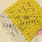
Camp Fornance
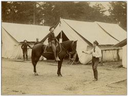
During the Spanish-American War, Camp Fornance was located around the area now known as Marshall Park.
From The NEGen Web Project:
This Camp was named for Captain James Fornance of the 13th United States Infantry Regiment who was mortally wounded on July 1st, 1898, near Santiago, Cuba, and died of his wounds on July 3rd. The Camp was abandoned in March of 1899. The camp was located in what was then north Columbia in an area later called the Camp Fornance section of the city. This area is generally the rectangle formed by U.S. Highway 176 and Richfield Drive and Union and Florence Streets. This area is identified on some maps as Camp Fornance at least as late as 1948.
Among those stationed at Camp Fornance were the men of the 2nd Tennessee Infantry. Most of the men stationed at Camp Fornance never saw combat during this war, and the camp was known as a Winter-readiness camp. This information and images from The Tennessee Secretary of State website.
Camp Dewey / Camp Geiger / Camp Fuller
Also from the The NEGen Web Project:
According to Moore, Columbia and Richland County, published by University of South Carolina Press, 1993, page 318, there [was another camp in this area of Columbia] for the state volunteers. Camp Dewey at Geiger’s Spring, in north Columbia, near where US highways 176 and 21 split. Geiger’s Spring was likely where Earlewood Park is located along north Main Street. This was slightly south and east of the Camp Fornance area. This was the camp of the Charleston Heavy Battery of the S.C. Vol. Artillery from May 25 to May 29, 1898.
Later references to this camp use the names Camp Geiger and Camp Fuller:
Camp Fuller, Columbia (Also known as Camp Geiger), Richland County
This Camp was named after Captain Ezra B. Fuller, who served as Chief Mustering Officer for the 1st South Carolina Volunteer Infantry Regiment, on October 30th, 1898. The Camp served as the Mustering out location for the 1st South Carolina from September 24th to November 12th, 1898. The Camp was located on the former site of Camp Dewey.
From Country to Suburb
At the turn of the 20th Century, Columbia was an exciting place. Columbia was a city that was on the move and growing. In the 1890s came the first electric powered textile mill on the banks of the Congaree, a result of the hydro-electric plant (still in use) on the Columbia Canal. And while electricity was lighting up the city, the trolley and automobile was expanding the city’s reach.
Commerce was exploding. An August 1915 article in The State included a list of the city’s achievements – 9 hotels, 10 colleges, 13 bank and trust companies, 9 railroad lines with 144 regular trains daily, boat line to the coast with tri-weekly sailings, 51 churches, 6 cotton mills (and the largest mill under one roof), 6 fertilizer factories and 60 other manufacturing plants, 27 miles of street car track and 57 cars (including one out North Main to then Broad River Road), 15 miles of sidewalks, 90 miles of streets, 41 sewerage mains, 51 water mains and 5 theaters.
Columbia’s population was over 56,000 people.
Camp Fornance Development Company
The growth of Columbia meant the need for more housing, and while the suburbs of Shandon on the east and Elmwood on the north had solidified, some of the same people that helped create those suburbs saw an opportunity in an area once known for its Spanish-American War encampment, Camp Fornance, in one of the highest areas of Columbia.
 Led by Francis H. Weston, the Camp Fornance Development Company in July 1910 purchased two tracts of property that would comprise more than 100 acres and create the foundation of what today is Earlewood.
Francis H. Weston, born in 1866, was a member of the Legislature, a trustee of then South Carolina College, a director of the Palmetto National Bank and in 1914 was appointed by President Woodrow Wilson (who also grew up in Columbia) as U.S. District Attorney. Weston was married to Amy Shoolbred. The Shoolbred family arrived in South Carolina in the early 1700’s and were large landowners in the state.
First Weston purchased 81.82 acres from what was formerly the Geiger Estate. The sellers were heirs of the John Kennedy estate, W.A. Clark and the South Carolina Agricultural Society. Then he purchased another 27.5 acres formerly owned by the Millers in an area called Columbia Heights. Price paid was about $50,000 for both tracts.
The Camp Fornance Development Company created a grid of rectangular blocks and placed 380 lots for sale in the newly named Camp Fornance subdivision. Lots were first sold toward the end of 1910 for $300 each and sales continued until the late 1920s. Many of the homes and gardens on the Bungalow Fest tour were part of this property.
 The new suburb of Camp Fornance lay west of Broad River Bridge Road (the name was changed to River Drive in 1925), its southern boundary was the Seaboard Airline Railroad and it abutted Alta Vista Farm (part of which is McCants School and Laurel Hill today) on the northwest.
In addition to the 360 lots, a park area – now Marshall Park – was reserved as well as the original site of the encampment. The first lots were sold on Columbia Avenue, Park Street (now Clark Street) and Lincoln Street. Based on the success of the Camp Fornance Development, the eastern portion of Alta Vista was laid out in lots between Lyles Avenue and Broad River Road in the 1920’s. Alta Vista consisted of 54.42 acres of undeveloped land and a school lot reserved for Fannie McCants School, which was built in 1931.
Earlewood
In the 1880’s several members of the Hook family bought about two hundred acres of land between the Broad River and North Main Street. Much of the land was along the Broad River Bridge Road, now called River Drive. The Newman family also owned hundreds of acres in north Columbia between the Broad River and the city. The Newman heirs took advantage of the success of the Camp Fornance subdivision and began selling their property from 1914 to 1937. And it was through the Newman family that some 80 acres of property between North Main Street and Broad River Road became Earlewood Park. This land was given to the city in 1925 and named for former Columbia mayor Fort Sumter Earle. F.S. Earle was a pharmacist by profession and a community leader who recognized the importance of public parks. Earle also spearheaded water and sewer development in Columbia.
National Humane Alliance Fountain
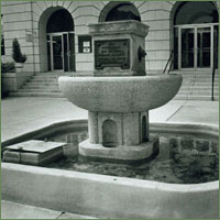 The National Humane Alliance Fountain was given to the City of Columbia in 1908 on the request of the Ladies of the Civic League of Columbia, led by Miss Belle Williams. It is one of 125 watering troughs/fountains presented to communities around the United States through an endowment from its founder, Herman Lee Ensign. The fountains are made of polished Maine granite, weigh about 5 tons and stand over six-feet high. The design has ornate lion head spigots on the sides and water flows from the mouths of the lions into a basin so that “man, horses and dogs may drink for all time to come”.
Originally located at the intersection of Lady and Assembly Streets, adjacent to the Farmer’s Market, this 5-ton fountain was moved to Earlewood Park after 1951, when the Market moved to Bluff Road. It was relocated to the Township Auditorium in 1980, but this historic fountain was returned to Earlewood Park in 2012. Former Earlewood Community Citizens Organization President Fred Monk and resident Elizabeth Davis Glover fought for years to bring the fountain back to Earlewood Park, and it is in Ms. Glover’s honor that the small garden around the fountain is named.
The Earlewood Community Citizens Organization is working to ensure that the fountain’s rich history is preserved for generations to come, and has erected the plaque detailing the story of the fountain and its significance to Earlewood and Columbia. If you would like to donate towards the purchase of the historical plaque and the marker to honor Mrs. Davis’s contribution to Earlewood, you may donate online. Donations of any amount are greatly appreciated.
To read more about the fountain returning to Earlewood Park, visit The State newspaper website.
To read more about the history of the National Humane Alliance fountains, visit the Derby, Connecticut website.
Growth of the Neighborhood
In the late 1920’s and early 1930’s Earlewood experienced another wave of growth as a result of the construction of the Lake Murray Dam. Work on the dam began in 1927 and by the time it was completed in July of 1930, over 5,000 people were relocated. Many of those displaced by the new dam purchased property in Earlewood.
The growth of Fort Jackson before and during WWII had a tremendous impact on the residential character of Columbia neighborhoods. During the 1940’s many of the single-family homes in Earlewood became duplexes and boarding houses in order to accommodate the housing demands of the soldiers and workers at Fort Jackson.
The end of World War II led to a boom in the growth of suburbs across America. Returning soldiers were ready to settle down and start families and the government provided low interest loans to help them buy houses in new residential developments. This had a negative impact on many downtown neighborhoods in Columbia, including Earlewood. As the population aged, Earlewood’s once-well kept homes and yards were neglected. The number of rental properties increased and more single-family homes were converted into duplexes. This downward trend continued until the 1990’s when graduate students, young professionals and empty nesters rediscovered Earlewood.
From Suburb to In-town Oasis – Earlewood Today
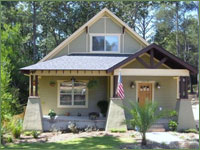 In recent years Earlewood has experienced a renaissance. Only a few minutes from The Vista and downtown Columbia it is an old neighborhood of tree-lined streets and Craftsman bungalows. The quality craftsmanship and construction of these historic homes has inspired young homeowners to renovate many of the bungalows in Earlewood.